23.202.150 R-BMU Residential BART Mixed Use District.
A. District Purpose. The purpose of the BART Mixed-Use (R-BMU) district is to create vibrant, well-designed, and welcoming neighborhoods that address City of Berkeley priorities such as affordable housing, civic and public space, multi-modal transportation and site access, high-quality building and site design and architecture, and a mix of land uses that contributes positively to the community, and to establish zoning standards in compliance with AB 2923.
B. Definitions. For the purpose of this Section (23.202.150), the following definitions apply:
1. Dwelling Units per Acre. The quotient resulting from the total number of dwelling units on a site divided by the Lot Area.
C. Allowed Land Uses.
1. General. See Section 23.202.020 (Allowed Land Uses), which indicates identified allowed land uses and which are prohibited.
(a) The initial establishment of a land use in a new building will follow the R-BMU Master Development Plan process outlined in Section 23.202.150.G below.
(b) The change of use of an existing building or portion of a building will require the permits indicated in Section 23.202.020 and Table 23.202-1 for the R-BMU District.
(c) Any use not listed in Table 23.202-1 for the R-BMU District can be approved through the Master Development Plan process outlined in Section 23.202.150.G below for the initial establishment of a land use in a new building.
(d) Uses subject to supplemental regulations are shown in Table 23.202-1 with an asterisk (*) following the permit requirement (e.g., ZC*). The Use-Specific Regulations column in Table 23.202-1 identifies the location of these regulations in the Zoning Ordinance.
2. Group Class Instruction and Gym/Health Clubs. Group class instruction and gym/health club uses are permitted at the Ashby BART station with a Zoning Certificate. Group class instruction and gym/health club uses are permitted at the North Berkeley BART station with a Use Permit.
3. Office. At the Ashby BART station, office uses above the ground floor are permitted with a ZC. All other office uses in the R-BMU require a Use Permit.
D. Ground-floor Uses. See Table 23.202-20: Permitted Street-Facing Ground Floor Uses.
FRONTAGE LOCATIONS | PERMITTED STREET-FACING GROUND FLOOR USES |
|---|---|
Along Ashby and MLK | Non-Residential Uses or non-residential accessory spaces to residential buildings, such as community rooms. At least 50% of the combined frontage of MLK and Ashby must include active ground -floor uses. [1] Active uses at corner locations are encouraged. |
Along Adeline | Non-Residential Uses or non-residential accessory spaces to residential buildings, such as community rooms. |
Along Woolsey, Tremont [2], or fronting interior public spaces | Residential or Non-Residential Uses |
Along Sacramento, along the Ohlone Greenway, or within 50 feet of any street corner | Residential or Non-Residential Uses |
Along Delaware, Acton, or Virginia | Residential Uses |
[1]Active uses are commercial uses in the following use categories: Retail; Personal and Household Services; Food and Alcohol Service, and Entertainment.
[2]Public entrances for non-residential uses fronting Tremont Street must be located on Woolsey Street.
23.202-3 PERMITTED STREET-FACING GROUND FLOOR USES
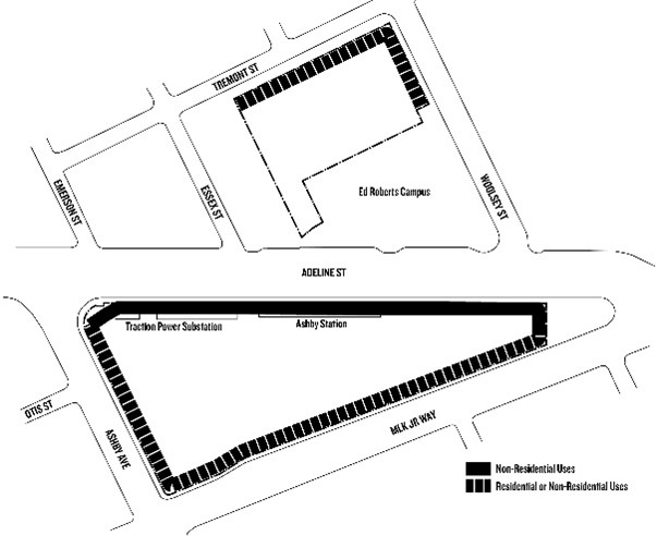
a. Ashby BART Station Site
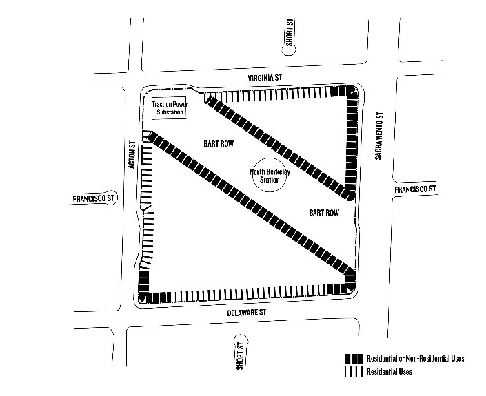
b. North Berkeley BART Station Site
E. Additional Permit Requirements. See Section 23.202.030 (Additional Permit Requirements).
F. Development Standards.
1. Basic Standards. See Table 23.202-21.
2. Supplemental Standards. Supplemental standards that apply in the R- BMU district are noted in Table 23.202-21.
|
SUPPLEMENTAL STANDARDS |
||
|---|---|---|
|
Lot Area, Minimum |
No minimum |
23.304.020-Lot Requirements |
|
Per Dwelling Unit |
40 sf/DU |
23.304.090-Usable Open Space |
|
Per Group Living Accommodation Resident |
15 sf/resident |
23.304.090-Usable Open Space |
|
Public Open Space, Minimum |
||
|
Per Dwelling Unit |
35 sf/unit |
|
|
Per Group Living Accommodation Resident |
18 sf/resident |
|
|
Floor Area Ratio (FAR), Maximum |
4.2 |
|
|
Main Building Height, Maximum [3] |
80 feet and 7 stories |
23.304.050-Building Height |
|
Residential Density, Minimum |
75 dwelling units per acre |
[1]Private Usable Open Space may be provided as any combination of personal and common private space.
[2]50% of the Private Usable Open Space requirement may be fulfilled through the provision of an equal amount of additional Public Open Space.
[3]Building Height Measurement: In the case of a roof with a parapet wall, building height shall be measured to the top of the roof and parapets may exceed the height limits by up to five feet by right.
3. Additional Open Space Requirements.
(a) Definitions.
i. Private Usable Open Space: Outdoor space, including natural and landscaped ground areas, playgrounds, pools, patios, decks and balconies designed for active or passive recreational use and which are accessible to the occupants of a building on the same development. See also 23.304.090 (Usable Open Space) for standards.
ii. Public Open Space: Outdoor space, including natural and landscaped ground areas, playgrounds, pools, fountains, patios, decks designed for active or passive recreational use and which are accessible to the general public. Minimum dimensions for Public Open Spaces shall be 20' in any direction and 400 square feet minimum.
(b) Public Space Design.
i. Land area made available for public access to and through the station, and on-site public amenities, may be offered as dedication to the City or may be owned and maintained by another party with dedication of a public access easement. Public Open Space must be accessible to the public during daylight hours and include signage indicating public access.
ii. Public spaces shall include site furnishings and design elements to encourage active or passive use.
iii. Public spaces shall have a direct, accessible connection to the public circulation network.
iv. Adjacent publicly owned space may contribute to the minimum public space requirement for the project, if it is designed, integrated and maintained as part of the project and complies with all other requirements for public space design identified in this section 23.202.150.F.3.b.
(c) Rooftop Open Space. Rooftops may be utilized as Private Usable Open Space or Public Open Space meeting the requirements of 23.202.150.F.3.a (Additional Open Space Requirements--Definitions). Rooftop space designated Public Open Space must also meet the requirements of 23.202.150.F.3.b (Public Space Design). No more than 25% of Public Open Space requirements can be met with Rooftop Open Space, and such Public Open Space must be independently accessible from the public circulation network.
4. Front Setbacks.
(a) Setbacks are not required at Martin Luther King Jr. Way, Adeline Street, Sacramento Street.
(b) Setbacks along all other frontages along public rights-of-way and internal publicly accessible pathways shall range from 5 feet (minimum) to 15 feet (maximum) for at least 50 percent of any building’s linear street frontage, including all frontages within 50 lineal feet of an intersecting corner.
5. Front Upper-Story Step-backs. Any street-facing building frontage above four stories in height that is not within 100 linear feet of Sacramento Street, Adeline Street, Ashby Avenue, or Martin Luther King Jr. Way, shall step back from the property line for portions of the building above four stories.
6. Ground-floor Residential Frontage. For ground-floor residential uses, outward facing building entrances may include any of the following: stoops, front doors, courtyard and forecourt entrances, ramped or at-grade universally accessible entries, outward-facing and visually permeable lobby entrances, or other outward-facing residential entrance, with transition spaces from private frontages to public spaces.
7. Ground-floor Non-Residential Frontage. For ground-floor non-residential uses, outward-facing building entrances and activation strategies may include outdoor seating, dining, display spaces, performance spaces, public art, architectural detailing, and extensions of the public sidewalk.
8. Frontage Improvements. Any area between a building and the front property line, or any area between a building and on-site public space or the public circulation network, shall be improved as part of a wider sidewalk, outdoor seating area, outdoor dining area, yard area, landscaping, or other usable open space.
9. On-site Pedestrian Access. Pedestrian accessways shall be provided for all new construction and for additions of 10,000 square feet or more of gross floor area in accordance with the following standards:
(a) Internal Connections. A system of publicly accessible pedestrian walkways (e.g. public sidewalks) shall connect all buildings on a site to each other, to on-site bicycle and automobile parking and drop-off areas, to any on-site open space areas or pedestrian amenities, and to the publicly accessible pedestrian circulation network.
(b) To the Public Circulation Network. A publicly accessible on-site walkway shall connect the building lobby entry or entries on each street or on-site pathway frontage to the public pedestrian circulation network. Connections to publicly accessible on-site walkways provided at least every 300 feet along portions of the development site perimeter that are adjacent to public rights-of-way.
(c) To Neighbors. Publicly accessible pedestrian access shall be provided from residential and commercial building entrances and public space to adjoining residential and commercial areas.
(d) To Transit. Publicly accessible pedestrian connections from the public circulation network shall be provided to all transit stops and entrances including elevators outside the station.
(e) Illumination. All publicly accessible pedestrian connections shall include nighttime illumination pursuant to Ordinance N.S.-7424.
10. Transparency.
(a) Required Openings. Ground-level exterior walls facing and within 20 feet of a front lot line or publicly accessible pathway or Public Open Space shall run in a continuous plane for no more than 30 feet without a window, door, or other similar building opening.
(b) Non-Residential Transparency. For non-residential ground-floor uses facing a front lot line, publicly accessible pathway or Public Open Space, a minimum of 50% of the building wall area located between three and seven feet above ground level shall be transparent with a visible light transmittance of not less than 80%.
11. Building Entrances.
(a) Minimum Number of Entrances Required. There shall be a minimum of at least one building entrance at an average distance of 50 linear feet of ground-floor non-residential building frontage, and at least one building lobby entrance for every 200 feet of ground-floor residential building frontage.
(b) Ground Floor Residential Entries. All ground floor residential units shall provide entries to the street in the form of stoops or other exterior entries, or balcony or patio without entrance to the street, with a minimum area of 20 square feet.
(c) Separate Entrances Required. Buildings containing a mix of residential and non-residential uses shall provide separate building entrances for each major use category. Amenity areas such as exercise rooms do not require separate building entrances from the primary use.
(d) Entrance Orientation. Principal building entrances shall face a public street, publicly accessible pathway, or Public Open Space.
(e) Illumination. Building entries and addresses shall be illuminated to provide nighttime visibility from adjacent streets, public accessways, and common areas.
12. Ground-Floor Non-Residential Space Dimensions. The minimum ground floor height for non-residential uses is 15 feet, as measured from the ground level floor to the first floor above.
13. Parking Design and Access.
(a) Unbundled Parking Required. All parking spaces shall be leased separately from the residential unit or commercial space except where prohibited by affordable housing financing sources.
(b) Structured Parking Required. All new off-street parking shall be located within an enclosed structure, with the exception of curb-side pickup and drop-off, curb-side metered parking, ADA parking, or small-scale surface parking for security and station operations and maintenance purposes only.
(c) Structured Parking Design. Parking garages shall be located underground or located behind conditioned building space at any adjacent street, sidewalk, or other publicly accessible accessway or open space. Conditioned building space is not required along shared interior lot lines of abutting parcels.
(d) Vehicular Entry. Parking garage vehicular entrances facing the street shall be no more than 20 feet wide.
(e) Pedestrian Entry. Parking garage pedestrian entrances shall be provided at-grade, connecting directly to the public pedestrian circulation network, on each street-facing frontage.
(f) Light Screening. Parking garages shall be designed such that interior lighting is fully shielded and automobile headlamps are not visible from adjacent buildings, parcels, streets, public parks, publicly accessible outdoor space or designated open space area.
14. Mitigation Measures. Projects under this section are subject to applicable measures identified in the adopted Mitigation Monitoring and Reporting Program of the Ashby and North Berkeley BART Stations Transit-Oriented Development Zoning Project Final EIR.
G. BART Mixed Use District Master Development Permit (MDP).
1. Purpose of the R-BMU District Master Development Permit (MDP) process. The purpose of these provisions is to prescribe the procedure for the review of initial development on parcels in the R-BMU District, in order to allow for the predictable buildout of the sites over time and achieve a high standard of affordability, site and building design that fulfills the City and BART Joint Vision and Priorities for the Ashby and North Berkeley BART Station Areas relating to:
•Affordable Housing
•Public and Civic Space
•Land Use
•Building Form and;
•Station Access.
2. Applicability of the Ashby and North Berkeley BART Master Development Permit (MDP). These provisions shall apply to all land within the R-BART Mixed Use District.
3. Preliminary Development Plan. The preliminary development plan shall include, at a minimum, the following:
(a) A plan of the entire development, defined as either the North Berkeley BART Station Area or Ashby BART Station Area, showing the items listed below. Such development plan shall include maps and information on the surrounding area within one hundred (100) feet of the development. All elements listed in this paragraph shall be characterized as existing or proposed, and sufficiently detailed to indicate intent and impact.
•Streets, driveways, sidewalks and pedestrian ways, and off-street parking and loading areas;
•Location and approximate dimensions of structures;
•Utilization of structures, including activities and the number of living units;
•Estimated population;
•Reservations for public uses, including schools, parks, playgrounds, and other open spaces;
•Placement of above-ground utilities such as electrical transformers, vents, and other mechanical equipment;
•Major landscaping features;
•Relevant operational data; and
•Drawings and elevations clearly establishing the scale, character, and relationship of buildings, streets, and open spaces.
(b) A table demonstrating that the plan meets the development standards set forth in Section 23.202.150.F and the other requirements of this Chapter, including compliance with any Objective Development Standards.
(c) A development phasing plan describing the order in which various portions of the development will be built, along with a proposed schedule for such phases.
4. Notice of Application and Public Hearing for Preliminary Development Plan.
(a) Preliminary Development Plans shall be reviewed by the Zoning Adjustments Board, the decisions of which are appealable to the City Council.
(b) The public notice and hearing process for a Master Development Permit shall be the same as for Use Permits as defined in BMC Section 23.404, except that notice shall be mailed or delivered to all businesses, residents and owners of property located within five hundred (500) feet of the subject property.
(c) The Board shall determine whether the proposal conforms to the permit criteria set forth in Section 23.202.150.G.8, and may approve or disapprove the application and the accompanying Preliminary Development Plan or require such changes therein or impose such reasonable conditions of approval as are in its judgment necessary to ensure conformity to said criteria and regulations. In so doing, the Board may, in its discretion, authorize submission of the Final Development Plan in stages corresponding to different units or elements of the development. It may do so only upon evidence assuring completion of the entire development in accordance with the Preliminary Development Plan and staged development schedule.
5. Final Development Plan. The applicant shall file with the Planning and Development Department a Final Development Plan for one or more of the phases identified in the Preliminary Development Plan.
(a) The Final Development Plan shall conform in all major respects with the approved Preliminary Development Plan and shall include the following additional information:
•Location of water, sewerage, and drainage facilities;
•Detailed building and landscaping plans and elevations;
•A maintenance plan for Open Space;
•Character and location of signs;
•Plans for street improvements; and
•Grading or earth-moving plans.
The Final Development Plan shall be sufficiently detailed to indicate the ultimate operation and appearance of the development, including compliance with the Objective Development Standards. Final Development Plans shall be reviewed by the Zoning Adjustments Board.
(b) The public notice and hearing process for a Final Development Plan shall be the same as for Use Permits as defined in BMC Section 23.406.040, except that notice shall be mailed or delivered to all businesses, residents and owners of property located within five hundred (500) feet of the subject property.
6. City Engineer’s Report. Within thirty (30) days after the filing of the Final Development Plan, the Zoning Officer shall forward it to the City Engineer for review of public improvements, including streets, sewers, and drainage. The Zoning Adjustments Board shall not act on a Final Development Plan until it has first received a report from the City Engineer or until more than thirty (30) days have elapsed since the plan and application were sent to the City Engineer, whichever is the shorter period.
7. Appeal to Council. The process for appeal to Council for a Master Development Permit, Preliminary Development Plan and/or Final Development Plan shall be the same as for Use Permits as defined in BMC Chapter 23.410.
8. Findings.
(a) That the location, design, size, and uses are consistent with the General Plan and with any other applicable plan, development control map, design guidelines, or ordinance adopted by the City Council;
(b) That the location, design, and size are consistent with the City of Berkeley and San Francisco Bay Area Rapid Transit District (BART) Joint Vision and Priorities document for the Ashby and North Berkeley BART Station Areas adopted by the City Council and the BART Board of Directors.
9. Adherence to the Approved Plan and Modification. Variations of up to ten percent (10%) from any numerical or non-numerical standard set forth on the Master Development Permit may be authorized by the Zoning Officer through an Administrative Use Permit. Variations of more than ten (10%) percent may be authorized by a Master Development Plan permit modification by the Zoning Adjustments Board.
10. Revocation of Permits. If a Final Development Plan for an initial portion of a site has not been submitted within 10 years after approval of the applicable Master Development Plan for all or a majority portion of the site, the City Council may revoke the approval of the remainder of the Master Development Permit. If Final Development Plans for the entirety of a site have not been submitted within 20 years after approval of the applicable Master Development Permit, the City Council may revoke the remainder of the Master Development Permit. (Ord. 7890-NS §§ 12, 13, 2023; Ord. 7850-NS §§ 4 — 12, 2023: Ord. 7815-NS § 5, 2022)